Comparative Cartography.

Discussion regarding the Outsider webcomic, science, technology and science fiction.

Moderator: Outsider Moderators

User avatar
Keklas Rekobah
Posts: 491
Joined: Fri Jul 23, 2021 7:54 pm

Comparative Cartography.

Post by Keklas Rekobah »

@Arioch: If the two mapping systems could be merged, how would this map...

Image

... fit with this map ...

Image

If you used something similar to the GURPS Traveller system to generate your map, the only issues would be rotation, distance, and scale.

The way I see it, if the two maps could be merged in one RPG setting, the Loroi Union would be rimward of the Hive Federation, and the Umiak Heirarchy would be rimward of the Aslan Heirate, with some overlap rimward of the Solomani Rim.

NOTE: The Traveller game in all forms is owned by Far Future Enterprises. Copyright 1977 – 2021 Far Future Enterprises (FFE).
“Qua is the sine qua non of sine qua non qua sine qua non.” -- Attributed to many

User avatar
icekatze
Posts: 1399
Joined: Sat Mar 05, 2011 8:35 pm
Location: Middle of Nowhere
Contact:

Re: Comparative Cartography.

Post by icekatze »

hi hi

Traveler doesn't really have much respect for the dimensions and layout of the real life galaxy like Outsider does, but you can merge these two maps together on your own without any trouble. The Traveler map and the Outsider map both have a scale in parsecs that you can match up.

Merging these two maps together, first thing you'll need to do is rotate Outsider map 90° counter clockwise. Then, you can check the cropped local bubble map and resize it until the scale matches. You'll find that the steppes region is far to the south of the Solomani Sphere, roughly in the middle of the Malorn area on the expanded map from Traveler.com. Umiak space clips the side of the Solomani sphere and takes up most of the Aslan Hierate. The Loroi Union cuts through the Drakken and Langere sectors of the Hive Federation.

User avatar
Arioch
Site Admin
Posts: 4485
Joined: Sat Mar 05, 2011 4:19 am
Location: San Jose, CA
Contact:

Re: Comparative Cartography.

Post by Arioch »

Assuming that the Traveller map is accurate (which I doubt), then matching scales and orientation relative to Earth looks like this:

Image

User avatar
Keklas Rekobah
Posts: 491
Joined: Fri Jul 23, 2021 7:54 pm

Re: Comparative Cartography.

Post by Keklas Rekobah »

I was hoping for just a tweak here and a tap there to get a good fit, but a blended campaign would require a major rework of canon for both settings, and is probably not worth the effort.  Stiil, thanks for the map!  It gives me a better idea of where the "Soiavesre" would be located in relation to the 3I.  Anyway, if the date is 2160 CE/1862 SYU, the time would be about IY -2360 -- 4 years after the 3rd Interstellar War between the Terran forces and the Ziru Sirka.
“Qua is the sine qua non of sine qua non qua sine qua non.” -- Attributed to many

User avatar
Keklas Rekobah
Posts: 491
Joined: Fri Jul 23, 2021 7:54 pm

Re: Comparative Cartography.

Post by Keklas Rekobah »

icekatze wrote:
Tue Aug 10, 2021 6:27 pm
hi hi
Amateur Radio?
icekatze wrote:
Tue Aug 10, 2021 6:27 pm
Traveller doesn't really have much respect for the dimensions and layout of the real life galaxy like Outsider does...
It is fair to point out that both systems are forced to present three-dimensional space in only two dimensions.  I have tried various 3-D presentations before -- including stacked hex-grids on transparent sheets -- but the displays quickly became muddled beyond a radius of about a dozen parsecs.
“Qua is the sine qua non of sine qua non qua sine qua non.” -- Attributed to many

User avatar
icekatze
Posts: 1399
Joined: Sat Mar 05, 2011 8:35 pm
Location: Middle of Nowhere
Contact:

Re: Comparative Cartography.

Post by icekatze »

hi hi

I certainly can't think of any good way to represent 3d space on a 2d surface for something that is as thick and cluttered as the galactic disk. It's either get a 3d program, or group things into smaller clusters.

(My using "hi hi" is something that I started up ages ago for trivial reasons. It's just a signature, except most forums don't support auto signatures at the top of the post.)

User avatar
Cthulhu
Posts: 910
Joined: Sat Dec 01, 2012 6:15 pm

Re: Comparative Cartography.

Post by Cthulhu »

icekatze wrote:
Wed Aug 11, 2021 12:20 am
I certainly can't think of any good way to represent 3d space on a 2d surface for something that is as thick and cluttered as the galactic disk. It's either get a 3d program, or group things into smaller clusters.
Well, even a 3D program will represent it on a 2D surface, the screen. Constantly rotating such a huge structure will be even more confusing, thus we'd need both 3D and smaller subunits. In the future, we would use holographic projectors, or perhaps VR? Would current VR systems display that properly?


There are also Holographic pyramids, but those are too small.

User avatar
Keklas Rekobah
Posts: 491
Joined: Fri Jul 23, 2021 7:54 pm

Re: Comparative Cartography.

Post by Keklas Rekobah »

↑ Yes, I have seen those, and even tried a few.  The problem is that while the image may look like it is projected above the base of the device, the image you see is not truly 3-dimensional -- you cannot look at the image from behind -- it is always the same flat image (actually 4, one for each side) no matter where the observer looks.  To see an object in 3D you must start with a 3D object (or a lot of computing power).

In CT, the average "jump map" is represented on a flat plane 6 scale parsecs in radius (13 across, including the parsec of origin).  If the scale is 2cm per parsec, the map is 26cm across (~10-1/4").  Extending this into a sphere yields a volume a little larger than a regulation basketball.  To use the "3D projector" above means pyramidal bowl about 30 cm across; but you would still end up with a flat diagram reflected in four orthogonal directions (actually 4 diagrams, one for each side).

The best representation of the celestial sphere I have seen involved stringing different-colored bead on black wires that had one end embedded in a baseboard.  Again, this becomes unwieldy or cluttered (depending on the scale) when anything larger than a "jump map" is involved.
“Qua is the sine qua non of sine qua non qua sine qua non.” -- Attributed to many

User avatar
Cthulhu
Posts: 910
Joined: Sat Dec 01, 2012 6:15 pm

Re: Comparative Cartography.

Post by Cthulhu »

I know that those pyramids a mere child's play, but it's the best 3D facsimile we have right now. At least for home use, because big projectors that use smoke or similar ones are way too expensive.

Otherwise, we can use VR, but it's still too limited now, too.

I don't think there are any programs that can convert those star charts to a VR-compatible imagery. While there are 3D starmaps, they obviously do not have any jump links or empire borders. I wonder if some open-source programs can be repurposed for that. I mean, there are even astrological ones.

The only thing we can do is to ask Arioch for a true Holoprojector and proper star charts from his Loroi comrades. :P

User avatar
Keklas Rekobah
Posts: 491
Joined: Fri Jul 23, 2021 7:54 pm

Re: Comparative Cartography.

Post by Keklas Rekobah »

Well, if we can accept faster-than-light travel and communications, cyborged bug people, hand-held lasers, and cold-blooded mind-witches with glowing eyes, then I think we can accept 2D starmaps.

I mean, Outsider is neither rocket science nor brain surgery; it is science-fiction, n'cest pas?  Arioch has gone far above and beyond what most artists would do to provide a back-story and consistent in-story science, and I (for one) appreciate it!

(Back on topic...)

I have seen some success with VR displays using forced perspective -- with either red/green filters, cross-polarization, or artificially-generated parallax -- and some of them have been very convincing.  Example: even though I knew it was a VR simulation, my eyes once told me that the F1 racecar I was in had gone over the edge of the Grand Canyon.  The bustards (grad students) running the sim told me that people on the floor above could hear me scream.

:oops:
“Qua is the sine qua non of sine qua non qua sine qua non.” -- Attributed to many

User avatar
Cthulhu
Posts: 910
Joined: Sat Dec 01, 2012 6:15 pm

Re: Comparative Cartography.

Post by Cthulhu »

Actually, there is a 3D star map of TCA space here, except that it doesn't work on modern browsers. Not that I'm complaining, anyway. Arioch has provided a treasure trove of background information. This, in turn, has led to a nice collection of fanart and fanfics. This is plenty enough already, although a complete holotank like the one on page 51 would be nice to have.
Perhaps, given some spare time, I can look into 3D programs for custom star chart imagery.

User avatar
Arioch
Site Admin
Posts: 4485
Joined: Sat Mar 05, 2011 4:19 am
Location: San Jose, CA
Contact:

Re: Comparative Cartography.

Post by Arioch »

The territory in Outsider does have a significant Z-axis components to it; as was said, this become unreadably cluttered when you zoom out beyond a specific region. Hopefully I can find a way to present this aspect in "side views" of some maps.

You can see the 3D element to it a bit in the shuttle starmaps.
p119 route from F to Seren.png
p119 route from F to Seren.png (124.22 KiB) Viewed 3861 times
It's a shame that the chview Java tool that I was using became deprecated and doesn't work on newer browsers. It was a very convenient tool. I'm sure there are others, but I have more important things on my plate at the moment.

User avatar
Keklas Rekobah
Posts: 491
Joined: Fri Jul 23, 2021 7:54 pm

Re: Comparative Cartography.

Post by Keklas Rekobah »

My group and I did some play-testing of a system wherein the stars' locations were given in {x,y,z} coordinates ({0,0,0} = Terra).  From these, the ship's navigator would have to determine the distance and heading {r,θ,φ} of the vessel before the pilot could initiate jump.  As the referee, I had the computer-generated solutions already worked out, which made for some "interesting" adventures when the players' ship finally precipitated from hyperspace.  While I never left them stranded in deep space, there was that one time their air became too foul to breathe, and the entire crew went unconscious just before being rescued...

;) (Great minds think alike, eh?)
“Qua is the sine qua non of sine qua non qua sine qua non.” -- Attributed to many

Dan Wyatt
Posts: 220
Joined: Fri Oct 16, 2020 6:17 pm
Location: Eurasia
Contact:

Re: Comparative Cartography.

Post by Dan Wyatt »

There is a 3D animated map of our stellar neighbourhood upto 10 persecs.
http://phl.upr.edu/projects/habuniverse

User avatar
Keklas Rekobah
Posts: 491
Joined: Fri Jul 23, 2021 7:54 pm

Re: Comparative Cartography.

Post by Keklas Rekobah »

↑ Very nice.

Cannot access background data.  If Arioch could edit the database to display the Soiaverse, then it would be an exceptional addition to this website.
“Qua is the sine qua non of sine qua non qua sine qua non.” -- Attributed to many

User avatar
Cthulhu
Posts: 910
Joined: Sat Dec 01, 2012 6:15 pm

Re: Comparative Cartography.

Post by Cthulhu »

But the maps are in the Insider database already? Or do you mean the chview files?

I think that Arioch has provided plenty of data already. Especially since he seems very busy the past few weeks.

User avatar
Keklas Rekobah
Posts: 491
Joined: Fri Jul 23, 2021 7:54 pm

Re: Comparative Cartography.

Post by Keklas Rekobah »

Cthulhu wrote:
Fri Aug 13, 2021 5:42 pm
But the maps are in the Insider database already? Or do you mean the chview files?
The 3D view will not display for me on any of my devices, and the 2D view is stationary (albeit very well done).
Cthulhu wrote:
Fri Aug 13, 2021 5:42 pm
I think that Arioch has provided plenty of data already.  Especially since he seems very busy the past few weeks.
Oh, I do not expect Arioch to make any new "fanservice" files for us astronomy geeks, as he has already gone well beyond what most webcomic artists will do.  I am only expressing a daydream I have had since I first start playing Traveller back around 1980.
“Qua is the sine qua non of sine qua non qua sine qua non.” -- Attributed to many

Kage Sama
Posts: 8
Joined: Fri Aug 13, 2021 11:27 pm
Location: Central MD, USA
Contact:

Re: Comparative Cartography.

Post by Kage Sama »

Keklas > Always great to find another long-term Traveller fan. I tried to work "Free Trader Beowulf" into a couple of Star Trek stories, but the editor kindly suggested I find another name for the ship. I always figured FT Beowulf would make a great Starfleet Intelligence ship posing as a free trader.

User avatar
Arioch
Site Admin
Posts: 4485
Joined: Sat Mar 05, 2011 4:19 am
Location: San Jose, CA
Contact:

Re: Comparative Cartography.

Post by Arioch »

Keklas Rekobah wrote:
Fri Aug 13, 2021 5:38 pm
Dan Wyatt wrote:
Fri Aug 13, 2021 3:38 am
There is a 3D animated map of our stellar neighbourhood upto 10 persecs.
http://phl.upr.edu/projects/habuniverse
Cannot access background data.  If Arioch could edit the database to display the Soiaverse, then it would be an exceptional addition to this website.
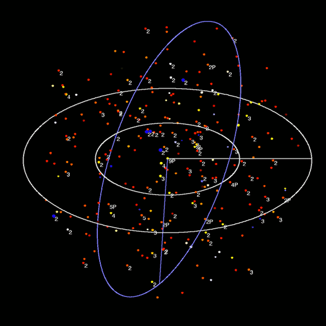
That's just an animated GIF image.

Image

The chview app embeds the star data in the HTML file, so if you view the source code on https://well-of-souls.com/outsider/map_terran.html, you can see the embedded data in the form:

Code: Select all

<param name=body001 value="Earth and Mars!!Sol!Sol!G2V!1.0000!0.00,0.00,0.00"> 
<param name=body004 value="Alpha and Proxima!!Alpha Centauri!Alpha Centauri A!G2V!1.1000!-1.69,-1.37,-3.89"> 
<param name=body006 value="!!Barnard's Star!Barnard's Star!M3.8V!0.1200!-0.06,-5.96,0.49"> 
<param name=body008 value="!!Wolf 359!Wolf 359!M5.8Ve!0.2000!-7.43,2.11,0.95"> 
etc.

The star data for this map was culled from a dataset provided by the app author(s); I'm not certain how accurate it is, but it appears to agree with other sources I have seen.

I'd like to get a new star database (I'm sure there are some good ones with the new Gaia measurements), but most give positions in RA/dec/distance. It's simple enough to convert those into 3D coordinates, but I need coordinates not in the celestial or ecliptic planes, but in the galactic plane. That probably requires a matrix transformation, which I never learned how to do (which is why I got a D in civil engineering). I'm sure I could find what I need somewhere out there, but I'm not going to spend my time or energy to do that right now.

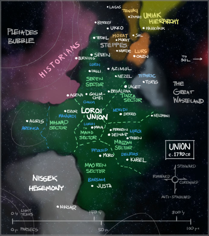
Also, while I like to build the maps on real star data wherever possible, I doubt that the dimmer red stars are properly represented at distances beyond 100 light years or so, so at least part of Union/Umiak territory maps are always going to have to be fictional.

gaerzi
Posts: 246
Joined: Thu Jan 30, 2020 5:14 pm

Re: Comparative Cartography.

Post by gaerzi »

icekatze wrote:
Wed Aug 11, 2021 12:20 am
I certainly can't think of any good way to represent 3d space on a 2d surface for something that is as thick and cluttered as the galactic disk. It's either get a 3d program, or group things into smaller clusters.
I like the way it was done in the old Frontier Elite II game. A perspective view (that you can pan and rotate freely) with tabs going to the reference plane.
Image
You can see that Barnard's Star or Ross 128 are "above" while Lalande 21185 or Epsilon Indi are "below".

Post Reply